

ICSE Solutions Voyage Class 7 Geography Chapter 12 Europe Location Area Political Physical Features have been provided below and is also available in Pdf for free download. The Voyage ICSE solutions for Class 7 Geography have been prepared as per the latest syllabus and ICSE books and examination pattern suggested in Class 7. Questions given in ICSE Voyage book for Class 7 Geography are an important part of exams for Class 7 Geography and if answered properly can help you to get higher marks. Refer to more Chapter-wise answers for ICSE Class 7 Geography and also download more latest study material for all subjects. Chapter 12 Europe Location Area Political Physical Features is an important topic in Class 7, please refer to answers provided below to help you score better in exams
Voyage Chapter 12 Europe Location Area Political Physical Features Class 7 Geography ICSE Solutions
Class 7 Geography students should refer to the following ICSE questions with answers for Chapter 12 Europe Location Area Political Physical Features in Class 7. These ICSE Solutions with answers for Class 7 Geography will come in exams and help you to score good marks
Chapter 12 Europe Location Area Political Physical Features Voyage ICSE Solutions Class 7 Geography
Think and Answer
Question. Why doesn’t Europe have a cold climate more similar to that of Alaska and northern Canada though it lies on the same latitudes ?
Answer: This happens because warm water currents travel north from the hot tropical areas toward Europe. There is very little contact with cold air or chilly ocean waters. Because of these warm currents, Europe is much warmer than Alaska or Northern Canada.
In simple words: Warm water from the tropics keeps Europe warmer than other places at the same level.
Exam Tip: Mention the role of warm ocean currents coming from the tropics to get full marks.
Values and Life Skills
Switzerland is one of the major tourist attractions. The Swiss government has taken many steps to make the country attractive for tourists from all over the world. The people also help to keep the country clean and secure.
Question. What does it tell us about the Swiss people? What can you learn from them?
Answer:
1. This shows that Swiss citizens are very smart. They take good care of the beautiful nature around them. They keep their cities neat and safe. This helps them welcome many visitors and earn a good living.
2. We can learn to keep our own towns and cities clean. We should also try to use our local resources in a smart way to help our community grow.
In simple words: The Swiss people teach us to keep our cities clean and safe. This helps to welcome visitors and make our country better.
Exam Tip: Always highlight the importance of cleanliness and civic sense when discussing values learned from Switzerland.
Exercises
A. Give geographical reasons
Question 1. Europe is rightly called the 'peninsula of peninsulas'.
Answer: Europe is surrounded by water on three sides. It has the Arctic Ocean in the north, the Atlantic Ocean in the west, and the Mediterranean and Black seas in the south. Since it is a large piece of land with many smaller peninsulas sticking out of it, it is known by this name.
In simple words: Europe has water on three of its sides. It also has many smaller lands pointing out into the sea, so it gets this name.
Exam Tip: Be sure to name the three bodies of water surrounding Europe (Arctic Ocean, Atlantic Ocean, and Mediterranean Sea) to get full marks.
Question 2. Belgium, the Netherlands, and Luxembourg are called the Low countries.
Answer: These three nations get this name because they are situated in flat, low-lying lands in the western part of Europe.
In simple words: These three countries are built on very low and flat land near the sea.
Exam Tip: Mention the term "low-lying plains" and specify their location in Western Europe.
Question 3. The Central European Plains are densely populated.
Answer: The soil in this area is very rich and fertile. This makes it perfect for farming, which is why so many people choose to live there.
In simple words: The land here is great for growing food. This is why many people build their homes in this area.
Exam Tip: Use the words "fertile soil" and "agriculture" to explain why people settle here in large numbers.
Question 4. The Caspian Sea is a lake.
Answer: Even though it is called a sea, it is technically a lake because land surrounds it completely on every side.
In simple words: It is called a sea, but it is actually a lake because land is all around it.
Exam Tip: Remember that a lake is defined as a body of water completely enclosed by land.
B. Give two examples from Europe for each of the following
Question B. Give two examples from Europe for each of the following
1. High peaks
2. Long rivers
3. Large freshwater lakes
4. Young fold mountains
5. Mediterranean countries
Answer:
1. Mt. Elbrus, Mont Blanc
2. Danube, Volga, Rhine
3. Lake Ladoga, Lake Vanern
4. The Alps, Sierra-Nevada
5. Spain, Portugal
In simple words: These are lists of famous mountains, rivers, lakes, and nations found in Europe.
Exam Tip: Memorize at least two examples for each category as they are very common in short-answer questions.
C. Answer the following questions in brief
Question 1. What are the chief physical divisions of Europe?
Answer: Europe has four primary geographic zones. These include:
(a) The Northern Mountains
(b) The Central European Plains
(c) The Southern Plateaux and Highlands
(d) The Alpine Mountain System
In simple words: Europe can be split into four main areas of land, ranging from high mountains to flat plains.
Exam Tip: List all four physical divisions with their correct names to secure full marks.
Question 2. Why are the Ural and Caucasus mountains important?
Answer: These two mountain ranges are highly significant because they form the boundary that divides Europe from Asia. The Ural range lies to the east, while the Caucasus range is located in the south-east.
In simple words: These mountains are important because they act as a natural border between Europe and Asia.
Exam Tip: Specify the directions (Ural in the east, Caucasus in the south-east) to show a precise geographical understanding.
Question 3. Name four countries bordering the Mediterranean Sea. Also name the capitals of these countries.
Answer: Four nations that touch the Mediterranean Sea, along with their capital cities, are:
- Spain - Madrid
- Portugal - Lisbon
- France - Paris
- Italy - Rome
In simple words: Four countries near this sea are Spain, Portugal, France, and Italy. Their main cities are Madrid, Lisbon, Paris, and Rome.
Exam Tip: When writing countries and capitals, present them clearly as a list so that it is easy to read.
Question 4. Identify two countries that belong to each of the following groups and state why they are so called:
1. Low countries
2. Balkan states
3. Scandinavian countries
Answer:
1. Low countries - These nations are located in the flat, low plains of Western Europe. Examples include Belgium and the Netherlands.
2. Balkan States - These countries lie within the Balkan Peninsula. Examples include Greece and Albania.
3. Scandinavian countries - These are the nations found in the far northern area of Europe. Examples include Norway and Sweden.
In simple words: This list groups European countries by where they are located and explains their group names.
Exam Tip: Be sure to state both the reason for the group name and give two clear examples for each group.
Question 5. Name any four major important cities of Europe.
Answer: Four key cities in Europe are:
1. London - This is the capital of the United Kingdom. It serves as a huge global trading hub and busy port.
2. Paris - This is the capital of France. It is famous for being a major center of art, science, and culture.
3. Berlin - This is the capital and largest city of Germany, and it serves as a key port on the river.
4. Moscow - This is the capital of Russia. It is built near a branch of the Oka River, which flows into the Volga.
In simple words: Major European cities like London, Paris, Berlin, and Moscow are important capitals and business centers.
Exam Tip: For each city you name, write a short sentence explaining why it is famous or important.
Question 6. What are fiords? How are they formed ?
Answer: Fiords are long, narrow, and deep passages of water with very steep sides. They cut into the coastline, making the shores of Scandinavia very uneven. They were created when rising water flooded valleys that were carved out by ancient glaciers.
In simple words: Fiords are deep, narrow water paths with high cliffs. They were made when seawater filled up old valleys made by ice.
Exam Tip: Remember to explain both what a fiord looks like and how ancient glaciers helped form them.
D. Answer the following questions in one or two paragraphs
Question 1. Briefly describe the location of Europe in relation to the other continents. What special advantage has Europe enjoyed due to its location?
Answer: Europe is situated near the center of the northern half of our planet. It has North America to the west across the Atlantic, Asia to the east, and Africa to the south. Its latitude goes from \( 35^\circ \text{N} \) to \( 73^\circ \text{N} \), meaning most of the continent is in the mild temperate zone. Longitudinally, it goes from \( 25^\circ \text{W} \) to \( 65^\circ \text{E} \).
Because of this location, Europe has a very favorable climate that is not too hot or too cold. Its long coastlines and nearby seas also made it very easy for European nations to trade and travel by ship to other parts of the world.
In simple words: Europe is right between North America, Asia, and Africa. Its location gives it a pleasant climate and great sea routes for trade.
Exam Tip: Always state both the exact coordinates (latitude and longitude) and the trade/climate benefits when discussing Europe's location.
Question 2. Write a short note on the capital city of Russia.
Answer: Moscow is Russia's capital city. It lies on a smaller river that flows into the Volga. The city is a major travel hub, with twelve railway lines and the end of the famous Trans-Siberian Railway. It serves as the main center for Russian government and industry. At the center of Moscow is Red Square.
On one side of this square stands Saint Basil's Cathedral, which has beautiful, brightly colored domes built back in the 1500s. Nearby is the final resting place of Lenin. The city is also home to the Kremlin, a historic fortress containing government offices, old churches, and palaces. There are also more than a hundred museums across the city.
In simple words: Moscow is the capital of Russia. It is a busy city with famous sights like the Red Square, beautiful old churches, and the Kremlin.
Exam Tip: Be sure to mention landmark features like the Kremlin, Red Square, and Saint Basil's Cathedral to write a complete note on Moscow.
Question 3. Describe the Northern Mountains of Europe.
Answer: These ancient mountains lie in the north and north-west parts of Europe, stretching from Norway and Sweden down to Scotland. They are made of very tough, solid rock. Long ago, they were incredibly tall and steep. However, ice sheets and glaciers have worn them down over millions of years, leaving behind lower hills with gentle sides. Along the shores, deep, flooded glacial valleys called fiords have made the coastline very jagged.
In simple words: These are very old, low mountains in northern Europe. Glaciers wore them down over millions of years and made deep water paths called fiords along the coast.
Exam Tip: Highlight that these are "old fold mountains" and explain how glaciers shaped them into low, gentle hills over time.
Question 4. Write a note on the Central European Plains.
Answer: This region is covered with soil left behind by ancient ice and rich silt from major rivers like the Volga, Don, Dnieper, and Ural. These lands are not completely flat, as they have gentle hills and rolling slopes. The soil is incredibly fertile, which makes it excellent for farming. Because of this rich land, some of the most crowded cities and communities in Europe can be found here.
In simple words: This is a hilly, green area with very rich soil made by rivers. Since it is great for farming, many people live here.
Exam Tip: Mention the names of key rivers (like the Volga and Don) that bring fertile soil to these plains, as this is a key detail examiners look for.
Question 5. Describe briefly the major young fold mountains of Europe.
Answer: The Alpine Mountain System is a series of young fold mountains located in southern Europe, reaching from the Atlantic Ocean in the west all the way to the Caspian Sea in the east. These mountains have very tall peaks, deep valleys, and steep, rocky sides. They run in several parallel lines, and events like earthquakes and volcanoes are frequent.
The Alps is the main mountain chain here, forming a curve that keeps Italy separate from France and Switzerland. Its tallest point is Mont Blanc at 4,807 meters. Other key ranges include the Pyrenees, which act as a border between Spain and France, and the Sierra Nevada in southern Spain.
In simple words: These are high, steep mountains in the south of Europe. The Alps and the Pyrenees are famous examples, and they often have earthquakes.
Exam Tip: Be sure to mention key features like Mont Blanc, the Pyrenees acting as a boundary, and the presence of parallel ranges.
Question 6. What is the significance of the many big and small rivers of Europe?
Answer: Many European rivers flow outwards in all directions from the Alps. These waters are deep enough for boats and are linked by canals to form an excellent water travel system. Because of this, numerous large cities have been built along their banks. These rivers are also very useful for factories and trade. Major rivers like the Volga, Danube, and Rhine cross multiple borders and are known as international rivers. The smaller rivers are also useful for local shipping and travel.
In simple words: Europe's rivers are linked by canals so boats can travel easily. They supply water to factories and help major cities grow along their sides.
Exam Tip: Define "international rivers" with examples (Volga, Danube, Rhine) to show how they connect different countries.
Question E. In your atlas, locate the major and minor rivers flowing through Europe. Note the names of important cities/towns that have developed on the banks of these rivers. Then tabulate your observations in your notebook using the headings given here:
1. Name of the river
2. Countries through which it flows
3. Important town/cities situated on its banks.
Answer: Here is a table listing major European rivers, the nations they cross, and key cities built along their banks:
| Name of the River | Countries through which it flows | Important town/cities situated on its bank |
|---|---|---|
| The Danube | Germany, Hungary, Serbia, Croatia, Austria, Slovakia, Romania and Bulgaria | Sofia, Trimisorra, Budapest, Vienna, Munich, Belgrade, Zagreb, Bratislava |
| The Elbe | Germany & Czech Republic | Dresden, Prague & Berlin |
| The Loire | France | Nantes, Lyon, Geneva |
| The Rhine | Switzerland, Liechtenstein, Austria, Germany, France & the Netherlands | Cologne, Koblenz, Strasbourg, boron, Mainz, Basel, Mannbein, Rhein, Duisburg |
| The Volga | Russia | Volgograd, Kazan, Saratou, Nizhny Novgorod, Astrakhan |
| The Don | Russia | Novomoskoosk, Tula, Rostov on Don |
| River Po | Italy | Monviso |
In simple words: This table shows where main European rivers flow and the well-known cities built next to them.
Exam Tip: Keep this table handy to quickly recall which major cities are situated on the banks of international rivers like the Danube and the Rhine.
Question F. The Scandinavian countries are generally considered to have a separate cultural identity. Form groups in your class and search the Internet to gather information on these countries and then hold a discussion under the following points:
1. employment
2. education
3. law and order
4. care for the aged
Answer: This is a classroom project. You can work with your classmates to search online about how Scandinavian countries handle jobs, schools, safety, and care for older people.
In simple words: You should find information online and discuss these topics with your classmates.
Exam Tip: When researching Scandinavian countries, focus on the "Nordic model" of welfare, which emphasizes high-quality public education and strong support systems for the elderly.
Question G. On the outline map of Europe, use different colours to mark and label the following:
1. Oceans - Arctic, Atlantic
2. Seas - Mediterranean, Baltic, North Sea
3. Straits - Dover, Gibraltar
4. Plateau - Central Massif, Meseta
5. Mountains - Alps, Pyrenees, Carpathians
6. Rivers - Danube, Rhine, Volga
7. Lakes - Ladoga, Onega, Vanern
8. Capitals - Paris, Moscow, Berlin
Answer: To complete this map work, look at the outline map of Europe. Use different colors to mark these key geographical features:
- Oceans: Place the Arctic Ocean at the far north, and the Atlantic Ocean to the west.
- Seas: Mark the Mediterranean Sea in the south, the Baltic Sea in the north-east, and the North Sea near Great Britain.
- Straits: Find the Strait of Dover between Britain and France, and the Strait of Gibraltar separating Spain from Africa.
- Plateaus: Label the Central Massif in southern France and the Meseta Plateau in Spain.
- Mountains: Shade the Alps in southern-central Europe, the Pyrenees on the Spanish-French border, and the Carpathians in the east.
- Rivers: Draw the routes of the Volga in Russia, the Danube crossing central Europe, and the Rhine in Western Europe.
- Lakes: Identify Lake Ladoga and Lake Onega in western Russia, and Lake Vanern in Sweden.
- Capitals: Mark the locations of Paris (France), Berlin (Germany), and Moscow (Russia).
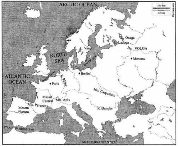
In simple words: Look closely at a map of Europe and use different colors to label these oceans, seas, mountains, rivers, lakes, and capital cities.
Exam Tip: Practice locating these features on a blank physical map of Europe regularly, as map marking is a high-scoring section in geography exams.
Question H. The photograph shows the highest peak in Europe.
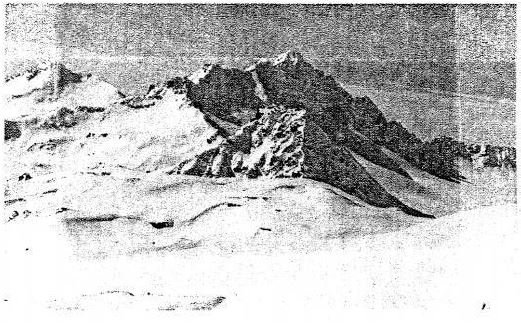
1. Name the peak.
2. Name the mountain range in which it lies.
Answer:
1. The mountain peak shown in the picture is Mt. Elbrus.
2. This peak is located within the Caucasus Mountains.
In simple words: The tallest mountain in Europe is Mt. Elbrus, and it is part of the Caucasus mountain range.
Exam Tip: Note the spelling of "Mt. Elbrus" and "Caucasus Mountains" carefully, as spelling errors on key names can lose marks.
Question. Refer to the physical map of Europe in your atlas. Moving in an anti-clockwise direction starting from the Arctic Ocean and the White Sea, observe and note down the names of all the surrounding water bodies such as seas, bays, gulfs, straits, etc. Then mark each of them on an outline map of Europe.
Answer: If we start at the White Sea and go in an anti-clockwise direction around Europe's coast, we will find these major bodies of water in order:
1. Barents Sea - lies in the far north, just off the coast of Russia and Norway.
2. Norwegian Sea - located to the west of Norway.
3. North Sea - situated between Great Britain and mainland Europe.
4. Baltic Sea - positioned in northern Europe, reaching up into the Gulf of Bothnia and Gulf of Finland.
5. English Channel - the narrow stretch of water dividing southern England from northern France.
6. Bay of Biscay - located off the western coast of France and northern Spain.
7. Strait of Gibraltar - the narrow channel connecting the Atlantic Ocean to the Mediterranean Sea.
8. Mediterranean Sea - the large body of water separating Europe from Africa.
9. Adriatic Sea - located between Italy and the Balkan Peninsula.
10. Aegean Sea - situated between Greece and Turkey.
11. Black Sea - a large sea bordered by southeastern Europe and Asia.
12. Sea of Azov - connected to the Black Sea in the far east.
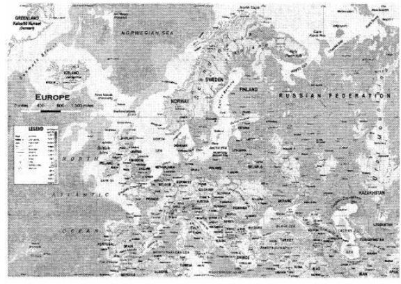
In simple words: Moving anti-clockwise around Europe, you start at the cold northern seas, go down the western coast into the warm Mediterranean Sea, and finish in the Black Sea in the east.
Exam Tip: Memorize the order of these water bodies sequentially around Europe's coastline to easily identify them on a blank map.
Free study material for Geography
ICSE Voyage Solutions Class 7 Geography Chapter 12 Europe Location Area Political Physical Features
Students can now access the detailed Voyage Solutions for Chapter 12 Europe Location Area Political Physical Features on our portal. These solutions have been carefully prepared as per latest ICSE Class 7 syllabus. Each solution given above has been updated based on the current year pattern to ensure Class 7 students have the most updated Geography content.
Master Voyage Textbook Questions
Our subject experts have provided detailed explanations for all the questions found in the Voyage textbook for Class 7 Geography. We have focussed on making the concepts easy for you in Chapter 12 Europe Location Area Political Physical Features so that students can understand the concepts behind every answer. For all numerical problems and theoretical concepts these solutions will help in strengthening your analytical skill required for the ICSE examinations.
Complete Geography Exam Preparation
By using these Voyage Class 7 solutions, you can enhance your learning and identify areas that need more attention. We recommend solving the Geography Questions from the textbook first and then use our teacher-verified answers. For a proper revision of Chapter 12 Europe Location Area Political Physical Features, students should also also check our Revision Notes and Sample Papers available on studiestoday.com.
FAQs
You can download the verified Voyage solutions for Chapter 12 Europe Location Area Political Physical Features on StudiesToday.com. Our teachers have prepared answers for Class 7 Geography as per 2026-27 ICSE academic session.
Yes, our solutions for Chapter 12 Europe Location Area Political Physical Features are designed as per new 2026 ICSE standards. 40% competency-based questions required for Class 7, are included to help students understand application-based logic behind every Geography answer.
Yes, every exercise in Chapter 12 Europe Location Area Political Physical Features from the Voyage textbook has been solved step-by-step. Class 7 students will learn Geography conceots before their ICSE exams.
Yes, follow structured format of these Voyage solutions for Chapter 12 Europe Location Area Political Physical Features to get full 20% internal assessment marks and use Class 7 Geography projects and viva preparation as per ICSE 2026 guidelines.