

ICSE Solutions Voyage Class 9 Geography Chapter 5 Landforms Of The Earth have been provided below and is also available in Pdf for free download. The Voyage ICSE solutions for Class 9 Geography have been prepared as per the latest syllabus and ICSE books and examination pattern suggested in Class 9. Questions given in ICSE Voyage book for Class 9 Geography are an important part of exams for Class 9 Geography and if answered properly can help you to get higher marks. Refer to more Chapter-wise answers for ICSE Class 9 Geography and also download more latest study material for all subjects. Chapter 5 Landforms Of The Earth is an important topic in Class 9, please refer to answers provided below to help you score better in exams
Voyage Chapter 5 Landforms Of The Earth Class 9 Geography ICSE Solutions
Class 9 Geography students should refer to the following ICSE questions with answers for Chapter 5 Landforms Of The Earth in Class 9. These ICSE Solutions with answers for Class 9 Geography will come in exams and help you to score good marks
Chapter 5 Landforms Of The Earth Voyage ICSE Solutions Class 9 Geography
I. Short Answer Questions
Question 1. What is meant by a landform ?
Answer: A landform refers to any natural shape or feature found on the earth's surface.
In simple words: A landform is simply any natural shape on the ground, like a hill, a valley, or a plain.
Exam Tip: Clearly mention that a landform must be a natural feature, not something built by humans, to get full marks.
Question 2. Why are the fold mountains called so ?
Answer: These highlands get their name because they form when large tectonic movements squeeze the crust. This pressure can come from heavy rocks on top, moving mantle layers, or the earth squeezing and stretching. The intense pressure pushes rock layers together, causing them to wrinkle or fold along weaker spots. When these rock folds rise up, they form mountains.
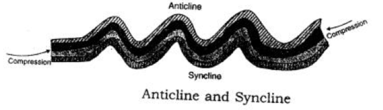
In simple words: These mountains are called "fold" mountains because the ground gets squeezed and wrinkles up like a rug.
Exam Tip: Use terms like "compressive forces" or "squeezing of rocks" to explain how the folds are made.
Question 3. Give two chief characteristics of the fold mountains.
Answer: 1. These mountain systems usually consist of ranges that run parallel to one another.
2. These areas are highly active and often experience sudden natural events like earthquakes and volcanic eruptions.
In simple words: Fold mountains are found in long parallel lines and often have earthquakes and volcanoes nearby.
Exam Tip: List two distinct points clearly using numbered bullets to make your answer easy for the examiner to read.
Question 4. Give one example of each : (a) Young fold mountains; (b) Old fold mountain. Why they are called so
Answer: (a) Young fold mountains: The Himalayas are a key example. They consist of light sedimentary rocks from the recent Tertiary period. They are the highest mountains on Earth and continue to grow taller because of ongoing upward forces.
(b) Old fold mountains: The Aravalli Range in India (or the Appalachians in North America) are examples. They are called old because they formed hundreds of millions of years ago and have been worn down by wind and water over a long time.
In simple words: Young fold mountains are tall and still growing, like the Himalayas. Old fold mountains are ancient and have been worn down over millions of years, like the Aravallis.
Exam Tip: Always provide a clear example for both types of fold mountains and briefly explain how their age affects their height.
Question 5. Give example of residual mountains.
Answer: A few examples include the Nilgiri, Parasnath, and Rajmahal Hills located in India, as well as the Catskill range found in the United States.
In simple words: Residual mountains are leftovers after wind and rain wear down higher land. Examples are the Nilgiri Hills in India and the Catskills in the USA.
Exam Tip: Name at least two Indian examples and one global example to show a thorough understanding.
Question 6. How is a rift valley formed ? Give one example of a rift valley.
Answer: A rift valley is created when a large block of land sinks downward between two parallel highlands or block mountains. An example of this is the valley where the Rhine River flows during its middle section.
In simple words: A rift valley forms when a huge piece of land drops down between two high cliffs. The Rhine Valley is a good example.
Exam Tip: Mention the sinking of land between block mountains to accurately describe the formation process.
Question 7. Give a brief definition of a plateau.
Answer: A plateau is an elevated area of flat land that rises sharply above the surrounding area on at least one side. It is also referred to as a tableland.
In simple words: A plateau is a high piece of land that is flat on top, like a table.
Exam Tip: Remember to use the keyword "tableland" when defining a plateau, as examiners look for this term.
Question 8. Give one example of each : (a) Intermontane plateau (b) Volcanic plateau and (c) Piedmont plateau
Answer: (a) Intermontane plateau: The Tibetan Plateau.
(b) Volcanic plateau: The Peninsular Indian Plateau (Deccan Plateau).
(c) Piedmont plateau: The Patagonian Plateau located in South America.
In simple words: Examples of these landforms are the Tibetan Plateau, the Deccan Plateau in India, and the Patagonian Plateau in South America.
Exam Tip: Ensure you match each type of plateau to its correct corresponding example.
Question 9. Give two points of importance of landforms.
Answer: 1. Landforms show how the earth's inner and outer forces work, creating diverse climates, forests, and snowy peaks that feed major rivers.
2. Coastal areas and islands serve as important fishing zones, and all these varied features make our planet a beautiful place to live and work.
In simple words: Landforms give us rivers, forests, and places to catch fish. They also make the Earth a beautiful place to live.
Exam Tip: Focus on how landforms provide resources like freshwater and support human activities like fishing.
Question 10. What are known as epeirogenic movements ?
Answer: Epeirogenic movements are vertical crustal shifts that cause land to rise or sink. The term comes from the Greek words "epeiros", which means continent, and "genic", which means building, because these actions helped raise continents out of the seas.
In simple words: Epeirogenic movements are vertical up-and-down movements of the earth's crust that help build continents.
Exam Tip: Explain the Greek origin of the word ("epeiros" and "genic") to make your definition complete and impressive.
Question 11. Name two landforms created by epeirogenic movements.
Answer: 1. Block mountains
2. Rift valleys and depressions
In simple words: Two shapes made by these movements are block mountains and rift valleys.
Exam Tip: Keep your list brief and direct as this is a straight identification question.
Question 12. Why are the sudden forces described as ‘Constructive forces ?
Answer: Sudden events like volcanic eruptions and earthquakes are called constructive forces because they build new features on the earth's surface. For instance, volcanic activity creates new mountains, vast plateaus, and flat plains.
In simple words: These forces are called "constructive" because they build new things on land, like volcanoes and plains.
Exam Tip: Give the example of volcanic eruptions building mountains and plateaus to explain the term "constructive".
Question 13. What are called endogenic forces ?
Answer: Endogenic forces are the internal pressure and movements that occur deep inside the earth, which are closely linked to tectonic activities.
In simple words: Endogenic forces are natural movements that happen deep inside the Earth.
Exam Tip: Remember that "endo" means internal; associate this force with tectonic activity inside the Earth.
Question 14. Name four relief features on the surface of the earth.
Answer: The four primary surface features of the earth are mountains, plateaus, plains, and valleys or basins.
In simple words: Four main landforms on Earth are mountains, plateaus, plains, and valleys.
Exam Tip: Be sure to list exactly four distinct landforms as requested by the question.
Question 15. What are known as exogenic forces ?
Answer: Exogenic forces are external processes driven by wind, water, and ice that slowly shape and wear down the earth's surface.
In simple words: Exogenic forces are outer forces like wind, rain, and ice that slowly change the shape of the land.
Exam Tip: Contrast exogenic (outer) forces with endogenic (inner) forces by highlighting that exogenic forces work on the surface.
Question 16. Name the two land forms produced by exogenic forces.
Answer: 1. Plains shaped by erosion and river deposits
2. Landforms created by glaciers
In simple words: Two shapes made by outside forces are plains made by rivers and valley shapes made by glaciers.
Exam Tip: Always use clear geological terms like "alluvial" or "glacial" when naming these landforms.
Question 17. Give one chief characteristic of the fold mountains.
Answer: A key feature of fold mountains is that they are created by horizontal pressure squeezing sedimentary rocks, which leaves visible layers stacked on top of each other.
In simple words: Fold mountains are made of stacked layers of rock that have been squeezed from the sides.
Exam Tip: Mention "lateral compression" (squeezing from the sides) and "sedimentary rock layers" for a complete answer.
Question 18. Give one example of volcanic mountains.
Answer: Volcanic mountains form when molten rock from inside the earth erupts onto the surface. A well-known example is Mount Krakatoa, an active volcano situated west of Java.
In simple words: Volcanic mountains form when hot lava erupts and cools. Mount Krakatoa in Indonesia is a famous example.
Exam Tip: Provide the name and location of a specific volcano, like Mount Krakatoa, to score full marks.
Question 19. How is a rift valley formed ? Give one example.
Answer: Rift valleys develop when a massive section of the earth's crust drops down between two elevated block mountains. For instance, the middle section of the Rhine River runs through a classic rift valley.
In simple words: A rift valley forms when a large piece of land sinks between two high cliffs, like the Rhine Valley.
Exam Tip: Describe the downward movement of the crustal block clearly as the primary cause.
Question 20. Give a brief definition of a plateau.
Answer: A plateau is an elevated flat area or tableland that sits higher than a valley but remains lower than a surrounding mountain range.
In simple words: A plateau is a high, flat area that is taller than a valley but shorter than a mountain.
Exam Tip: Describe a plateau in relation to its height compared to mountains and valleys.
Question 21. Give one example of each (a) Intermontane plateau (b) Piedmont plateau (c) Volcanic plateau.
Answer: (a) Intermontane plateau: The Tibetan Plateau.
(b) Piedmont plateau: The Patagonian Plateau of South America.
(c) Volcanic plateau: The Deccan Plateau of Peninsular India.
In simple words: Examples of these three plateaus are the Tibetan, Patagonian, and Deccan plateaus.
Exam Tip: Make sure to match each plateau type with its correct geographic example.
Question 22. How are erosional plains formed ?
Answer: These plains are created over millions of years as wind, water, and ice wear down higher landforms until they become flat. The Lorraine Plain in France is a clear example.
In simple words: Erosional plains are made over millions of years as wind and water flatten tall hills into low, level land.
Exam Tip: Mention both the time scale (millions of years) and an example like the Lorraine Plain to write a perfect answer.
Question 23. Give two points of importance of landforms.
Answer: 1. Landforms illustrate the impact of tectonic and surface forces, shaping unique climates, rich forests, and high glaciers that supply water to rivers.
2. They also offer crucial areas for human livelihood, such as coastal zones for fishing, making our planet habitable and scenic.
In simple words: Landforms give us rivers, trees, and seas for fishing, while making our world a beautiful home.
Exam Tip: Explain the importance in terms of both natural resources (like rivers) and human benefits (like fishing).
II. Distinguish Between Each of the Following
Question 1. Distinguish between Fold Mountain and Block Mountain.
Answer: Fold Mountain:
1. These are created when tectonic forces squeeze and bend layers of sedimentary rock.
2. They are made of lighter sedimentary rock layers, such as the Himalayas.
Block Mountain:
1. These form when a large block of land sinks, leaving tall blocks standing on either side.
2. They consist of solid, hard rock structures found on both sides of a rift valley, like the Vosges Mountains in France.
In simple words: Fold mountains form when rock layers bend and wrinkle up. Block mountains form when a piece of land sinks, leaving flat, steep cliffs behind.
Exam Tip: Provide at least one specific example for both types of mountains when distinguishing between them.
Question 2. Distinguish between Intermontane plateau and Volcanic plateau.
Answer: Intermontane Plateau:
These are the tallest and largest plateaus on Earth, completely enclosed by mountain ranges. The Tibetan Plateau is the most prominent example. Other examples include the Bolivian and Mexican plateaus.
Volcanic Plateau:
These form when lava flows smoothly out of long cracks in the ground over many kilometers. This lava spreads out and cools into flat sheets, which stack up over time during repeated eruptions. The Deccan Trap in India is a volcanic plateau with stacked lava layers. Other examples include the Ethiopian Plateau.
In simple words: Intermontane plateaus are very high flatlands surrounded by mountains. Volcanic plateaus are made of cooled lava sheets stacked on top of each other.
Exam Tip: Mention that intermontane plateaus are "surrounded by mountains" and volcanic plateaus are formed from "fissure eruptions of lava".
Question 3. Distinguish between Structural plain and Depositional plains.
Answer: Structural Plain:
These are formed when deep-seated earth forces lift up a large part of the sea floor or landmass to create a wide lowland. An example is the Missouri-Mississippi Plain in the United States.
Depositional Plains:
These are created when natural forces like wind, water, or ice deposit sand, soil, and debris over an area. They include:
1. River Deposition: Alluvial plains created by rivers, like the Northern Plains of India.
2. Wind Deposition: Sandy desert plains with dunes, like the Sahara Desert.
3. Marine Deposition: Flat coastal plains formed by sea action, like the eastern coast of India.
In simple words: Structural plains are made when the Earth lifts up the sea floor. Depositional plains are built from mud, sand, or soil left behind by rivers, wind, or the sea.
Exam Tip: When writing about depositional plains, list the three main agents (rivers, wind, and sea) along with an example for each.
Question 4. Distinguish between Tectonic mountain and Volcanic mountain.
Answer: Tectonic Mountain:
1. It is formed by tectonic pressure acting on the earth's crust.
2. It results from the upward push of crustal movements.
3. It is typically composed of sedimentary or metamorphic rocks.
Volcanic Mountain:
1. It is built by volcanic eruptions coming from deep within the earth.
2. It is created as molten magma rises and cools on the surface.
3. It is made of crystalline igneous rocks.
In simple words: Tectonic mountains form when the earth's crust gets pushed up. Volcanic mountains form from cooled lava and ash.
Exam Tip: Contrast the rock types: tectonic mountains are usually sedimentary or metamorphic, while volcanic mountains are igneous.
III. Give One Technical Term for Each of the Following
Question 1. Block mountains with flattened summits.
Answer: Horst mountains
In simple words: These are called Horst mountains.
Exam Tip: Horst is the exact geographical term for an uplifted flat-topped block.
Question 2. Plateaus surrounded by hills and mountains on all sides.
Answer: Intermontane plateaus
In simple words: These are called intermontane plateaus.
Exam Tip: Remember "inter" means between, so "intermontane" means between mountains.
Question 3. Plateaus formed by lava.
Answer: Volcanic plateaus
In simple words: These are called volcanic plateaus.
Exam Tip: Make sure to use the correct spelling "volcanic" and explain that these are built from lava flows.
Question 4. An extensive area of lowland with a level or gently undulating surface.
Answer: Plains
In simple words: These flat areas are called plains.
Exam Tip: A plain is defined by its low height and flat or gently rolling ground.
Question 5. The compressional forces that cause folding of rocks and formation of fold mountains.
Answer: Diastrophic forces
In simple words: These are called diastrophic forces.
Exam Tip: These long-term, slow-moving crustal forces are known as diastrophic forces.
Question 6. The vertical movements which are the result of faults and cracks in the surface of the earth.
Answer: Epeirogenic movements
In simple words: These are called epeirogenic movements.
Exam Tip: Epeirogenic movements act vertically to lift or lower parts of the earth's crust.
Question 7. The forces operating on the surface of the earth.
Answer: Exogenic forces
In simple words: These are called exogenic forces.
Exam Tip: Exogenic forces are external forces driven by elements like wind and water.
Question 8. Plateaus surrounded by mountains on one side and plains on the other.
Answer: Piedmont plateaus
In simple words: These are called piedmont plateaus.
Exam Tip: A piedmont plateau lies at the foot of a mountain and borders a plain or sea on the other side.
Fill in the Blanks with Suitable Words
Question 1. Volcanic activity is a ________ movement.
Answer: sudden
In simple words: Volcanoes erupt very quickly, so they are sudden movements.
Exam Tip: Volcanic eruptions and earthquakes are classic examples of sudden earth movements.
Question 2. The upfolds of the rock strata are called ________.
Answer: anticlines
In simple words: The upward folds of rocks are called anticlines.
Exam Tip: Remember that upfolds are anticlines and downfolds are synclines.
Question 3. The Mid-Atlantic Ridge rises ________ km above the floor of the Atlantic.
Answer: 3
In simple words: The ridge rises 3 kilometers high.
Exam Tip: Keep the exact numeric value (3 km) in mind for factual fill-in-the-blank questions.
Question 4. The Great Plain of the USA was formed by ________ forces.
Answer: Diastrophic
In simple words: This plain was made by slow diastrophic forces.
Exam Tip: The Great Plain of the USA is a structural plain formed by tectonic/diastrophic uplift.
Question 5. The Great Northern plains of India were formed by ________.
Answer: River Deposition
In simple words: These plains were built by soil left behind by rivers.
Exam Tip: The Northern Plains of India are classic depositional plains formed by the Indus, Ganga, and Brahmaputra rivers.
IV. Long Answer Questions
Question 1. Describe the formation of mountains and their types.
Answer: Mountains are grouped into three primary categories depending on the geological forces that created them:
1. Fold Mountains: These are formed due to major tectonic shifts that create intense pressure in the earth's crust. This lateral pressure, caused by mantle convection, rock weight, or crustal changes, squeezes sedimentary rock layers. This compression produces folds and wrinkles along weaker lines, elevating into mountains.
2. Residual Mountains: These are older mountains that have been heavily eroded over millions of years by natural forces like wind, rain, and snow. While the surrounding land is worn flat, harder and more resistant rock structures remain standing as hills. Examples include the Nilgiri Hills in India and the Catskills in the USA.
3. Block Mountains: Also known as horsts, these form when vertical movements along cracks in the crust push a central block of land upward or cause the flanking blocks to sink, leaving behind a flat-topped highland with very steep sides. Examples include the Vosges Mountains situated west of the Rhine Valley and the Black Forest on the east.
In simple words: Mountains are made in three ways: by bending rock layers (fold mountains), by weathering away softer parts of old mountains (residual mountains), or by lifting up big blocks of land along fault lines (block mountains).
Exam Tip: Use clear diagrams for fold, residual, and block mountains to score maximum marks in long-form questions.
Question 2. Describe the characteristics of four different types of plateaus.
Answer: The four primary categories of plateaus include:
1. Intermontane Plateaus: These are the highest tablelands on the planet, completely enclosed by massive mountain chains. A famous example is the Tibetan Plateau.
2. Piedmont Plateaus: Located at the base of mountains, these slope sharply toward the plains, shaped over time by descending rivers. Examples include the Patagonia Plateau in South America and the Appalachian Plateau in the USA.
3. Volcanic Plateaus: These are formed by quiet volcanic eruptions where layers of lava flow out of fissures and cool on the surface. The Deccan Plateau in India is a key example.
4. Uplifted Plateaus: Created by internal tectonic forces that push up the crust into dome-shaped highlands, such as the Chhotanagpur Plateau in India.
In simple words: The four types of plateaus are intermontane (surrounded by mountains), piedmont (between mountains and plains), volcanic (made of cooled lava), and uplifted (pushed up by inner earth forces).
Exam Tip: For each plateau type, describe its distinct formation process and provide at least one geographical example.
Question 3. Describe the characteristics of structural plains.
Answer: Structural plains are formed when slow, internal earth movements lift a massive portion of the seafloor or low-lying land. An example of this is the Great Plain of the USA.
In comparison, other plain types include:
- Erosional Plains: Formed when weathered highlands are flattened over time by agents like wind (e.g., Sahara Desert plain), ice (e.g., Srinagar Valley in Kashmir), or groundwater dissolving limestone (e.g., Karst Plains of Yugoslavia).
- Depositional Plains: Created when rivers or other transporting agents lay down silt and sand across an area, such as the Northern Plains of India.
In simple words: Structural plains are made when tectonic forces lift up large sections of the sea floor. Other plains are shaped by erosion wearing down hills or rivers depositing mud.
Exam Tip: Even though the question asks about structural plains, mentioning the other types (erosional and depositional) shows a complete understanding of plains.
Question 4. Explain the chief characteristics of depositional plains and their types.
Answer: Depositional plains are built up by sediments transported and laid down by different natural agents. They are classified into three major groups:
1. River Deposition: These are widespread alluvial plains, including the Northern Plains of India, the Mississippi flood plains in the USA, and deltaic plains in Egypt.
2. Wind Deposition: These form sandy desert landscapes with undulating surfaces, sand dunes, and hollows, such as the Sahara in Africa and the Thar Desert in India.
3. Marine Deposition: Found along coastal zones where waves pile up sand and silt, seen along the eastern coast of India and the German-Danish coasts.
In simple words: Depositional plains are formed when wind, rivers, or ocean waves drop sand and mud, building up flat areas over time.
Exam Tip: Clearly distinguish between river, wind, and marine deposition with relevant geographic examples for each type.
Question 5. Give a brief account of importance of landforms on the surface of the earth.
Answer: Landforms are essential for human life and activities as they shape climates, landscapes, and natural resources. Snowy mountain ranges and glaciers act as the source of major rivers, while diverse forest zones supply valuable timber and organic products. Additionally, plains offer fertile ground for farming, while the scenic beauty of these geological structures boosts global tourism, making our planet a highly habitable and rich environment.
In simple words: Landforms give us rivers, trees, and flat land for farming, while their natural beauty attracts tourists from all over the world.
Exam Tip: Focus on how different landforms support specific human needs, like plains for farming and mountains for freshwater.
Practice Questions (Solved)
Question 1. Describe the direction in which the following mountain systems lie and also point out the continents where they are found. (a) Alpine Himalayan System (b) Rocky-Andean System
Answer: (a) Alpine-Himalayan System: These mountain belts stretch horizontally from West to East across the continents of Europe and Asia.
(b) Rocky-Andean System: These mountain systems run vertically from North to South along the western coastlines of North and South America.
In simple words: The Alpine-Himalayan mountains run west-to-east in Europe and Asia. The Rockies and Andes run north-to-south along the west sides of the Americas.
Exam Tip: Be precise about the directional alignment (West-East vs. North-South) and continental locations for both mountain systems.
Question 2. Describe the different stages in the growth of mountains.
Answer: Mountain building occurs in three key phases:
1. The Geosyncline Stage: Soil and sand accumulate over a long period on the seabed, forming deep, sediment-filled depressions.
2. The Orogenic Stage: Lateral tectonic forces squeeze and compress these accumulated sediments, buckling them into folds.
3. The Epeirogenic Stage: The folded mass is elevated vertically, creating a pattern of valleys (synclines) and mountain ridges (anticlines).
In simple words: Mountains grow in three steps: first mud collects under the sea, then earth movements squeeze it into folds, and finally it gets lifted high into ridges and valleys.
Exam Tip: State the three stages in order: Geosyncline, Orogenic, and Epeirogenic, defining each phase clearly.
Question 3. What are the different types of Geosynclines ?
Answer: Geosynclines are classified into three types based on their size and location:
1. Monogeosynclines: These are long, narrow depressions found along confined water bodies, eventually forming narrow ranges like the Appalachians of North America.
2. Polygeosynclines: These form in massive, wide ocean basins, leading to wide and expansive mountain systems like the Rockies.
3. Mesogeosynclines: These sit between major continental masses, such as the basin between Europe and Africa that formed the Alps, Pyrenees, and Atlas mountains.
In simple words: There are three kinds of geosynclines: monogeosynclines (narrow), polygeosynclines (wide), and mesogeosynclines (located between continents).
Exam Tip: Link each type of geosyncline with its characteristic shape and a real-world mountain range as an example.
Question 4. Write a note on the characteristics of folded mountains.
Answer: Fold mountains are created by lateral compression and twisting of the crust, creating a series of upward folds (anticlines) and downward folds (synclines). Over time, these elevated areas are carved by wind and water erosion. The tallest mountain ranges on Earth are fold mountains, primarily composed of sedimentary rocks.
In simple words: Fold mountains are built from squeezed rock layers that look like waves. They are the highest peaks on Earth and are made of sedimentary rock.
Exam Tip: Highlight that fold mountains are made of sedimentary rocks and feature a series of anticlines and synclines.
Question 5. What are Block mountains ? How are they formed ?
Answer: Block mountains are elevated, flat-topped landmasses that stand on either side of a rift valley. They are created when fault lines develop in the crust and tectonic forces cause the central section of land to sink down, leaving the adjacent blocks standing high. This movement along geological faults is called faulting.
In simple words: Block mountains are high, flat cliffs that stand next to a deep rift valley where the ground has sunk down.
Exam Tip: Make sure to use the term "faulting" to describe the geological process that creates block mountains.
Question 6. How can mountains be classified according to their different size and arrangement ? Describe in detail two of the classes of such mountains.
Answer: Mountains are broadly categorized into four main classes: Fold, Block, Volcanic, and Relict mountains. Two of these are described below:
- Volcanic Mountains: These are built when hot magma erupts from inside the earth and accumulates on the surface. Depending on how they are constructed, they form lava cones, ash cones, or composite cones, such as Mount Fuji in Japan.
- Relict (Residual) Mountains: These are formed when old, hard rock structures are slowly worn down over millions of years by weathering and erosion. The result is rounded hills made of dense rocks, such as the Vindhyachal range in India.
In simple words: Mountains can be fold, block, volcanic, or relict. Volcanic mountains form from erupted magma, while relict mountains are the eroded remains of old highlands.
Exam Tip: In detailed questions, define the classes clearly and provide well-known examples like Mt. Fuji and the Vindhyachal Range.
Question 7. What are Block mountains ? How are they formed ?
Answer: A block mountain, or horst, is an elevated crustal block lying between two faults. It is formed when the central block is pushed upward (upthrown) or when the outer blocks of land drop downward (downthrown), leaving the middle section elevated. It has a flat, plateau-like top and very steep edges. Examples include the Vosges Mountains and the Black Forest on either side of the Rhine Rift Valley.
In simple words: A block mountain (horst) is a flat-topped highland with steep sides that forms when the surrounding land drops down along fault lines.
Exam Tip: Draw a simple block diagram showing the Horst (upthrown block) and the Graben (downthrown rift valley) to secure full marks.
Question 8. How can mountains be classified according to their different size and arrangement ?
Answer: Mountains can be classified based on their size, structural pattern, and layout into the following categories:
1. Cordilleras: These are vast, expansive mountain regions made up of numerous interconnected chains and ranges.
2. Mountain System: A collection of related mountain ranges that share similar origins, ages, structures, and positions, though separated by basins or trenches.
3. Chain: A straight, continuous line of mountain ridges separated only by deep, trough-like valleys.
4. Range: A linear series of many peaks and ridges separated by valleys, sharing a common age and structural origin.
5. Group: A circular, dense cluster of mountain peaks, often formed by the erosion of subsurface igneous intrusions (laccoliths).
6. Ridge: A single, narrow elevated block or fold resulting from crustal faulting and folding, with steep slopes on its sides.
7. Peaks: Single, pointed summits formed by resistant rock layers that have withstood erosion. They can be dome-like, needle-shaped, or pyramid-shaped depending on rock joints.
In simple words: Mountains are grouped by their layout: a cordillera is a massive network, a range is a single line of peaks, a system is a group of related ranges, and peaks are individual summits.
Exam Tip: Be ready to define terms like "Cordillera" and "System" as they are frequently asked as short-answer questions.
Question 9. What are plateaus ? How are they different from mountains ? Give suitable examples.
Answer: Plateaus, also known as tablelands, are broad, flat-topped highlands that rise sharply above the surrounding lower areas. In contrast, a mountain is a highly elevated point or ridge with steep slopes and a distinct peak, rising much higher than its surroundings.
Examples of Plateaus:
1. The Deccan Plateau in India.
2. The Tibetan Plateau, which is often called the "roof of the world."
In simple words: A plateau is a high, flat tableland, while a mountain has a pointed peak and steep slopes.
Exam Tip: Clearly state that plateaus are flat-topped (tablelands) whereas mountains are pointed (peaks) to highlight the main difference.
Question 10. What is a Piedmont Plateau ? How is it different from a Continental plateau ? Give suitable examples to illustrate.
Answer: Piedmont Plateaus:
These plateaus are situated at the foot of mountain ranges, bordered on one side by mountains and on the other by plains or the ocean. Key examples include the Colorado Plateau in North America and the Patagonian Plateau in South America.
Continental Plateaus:
These are vast, massive elevated tablelands that rise steeply from the surrounding lowlands or directly from the sea, typically lacking mountainous borders. Major examples include the continental landmasses of Africa, Arabia, Spain, Peninsular India, and Western Australia.
In simple words: Piedmont plateaus lie at the bottom of mountains next to plains. Continental plateaus are massive flat areas that rise straight out of the lowlands or the sea.
Exam Tip: Contrast the boundaries: Piedmont plateaus have mountains on one side, while continental plateaus rise directly from lowlands or the sea without mountain rims.
Question 11. Write short notes on the following : (a) Coastal plains (b) Karst plains (c) Peneplain (d) Cuestiform plains.
Answer: (a) Coastal Plains: These are wide, flat lowlands situated near sea coasts, created when the sea floor is elevated. They consist of loose layers of sand and mud, and often grow wider as ocean waves deposit more material over time.
(b) Karst Plains: These are flat-bottomed plains created when groundwater dissolves limestone or chalk bedrock. Over time, wind weathering shapes the rocks into unique, rounded, or polished fragments scattered across the surface.
(c) Peneplains: These are extremely low, gently rolling plains formed toward the end of an erosion cycle, where the land is worn down to near sea level.
(d) Cuestiform Plains: These are marked by circular patterns of alternating ridges and lowlands, typically created by rivers carving through bands of hard and soft rock. Examples include the basins surrounding Paris and London.
In simple words: Coastal plains form along the sea from rising seabeds. Karst plains form where groundwater dissolves limestone. Peneplains are nearly flat from long-term erosion. Cuestiform plains have rolling ridges carved by rivers.
Exam Tip: For each term, focus on the primary force involved (e.g., sea waves for coastal, groundwater for karst, river action on hard/soft rock for cuestiform).
Question 12. Why and how are the plains the centres of all human activity ?
Answer: Plains have historically served as the centers of human civilization and economic development because of several key advantages:
1. Transportation: The flat terrain makes it very easy to build railways, roads, and canal networks.
2. Agriculture: They offer highly fertile soil, earning them the reputation of being the world's primary food baskets.
3. Living Conditions: Because of the pleasant climate, rich soil, and ease of mobility, plains support dense populations, with almost all of the world's major cities located on flat lowlands.
In simple words: Plains are where most people live because the flat ground is perfect for building roads, growing food, and living comfortably.
Exam Tip: Use terms like "cradles of civilization" and "granaries of the world" to emphasize the historical and agricultural importance of plains.
Question 13. Differentiate between Young fold mountains and Old fold mountains.
Answer: Old Fold Mountains:
These mountains were formed more than 250 million years ago. Due to hundreds of millions of years of exposure to wind and water, they have low heights and gentle slopes. Examples include the Ural Mountains in Russia, the Appalachians in North America, and the Aravalli Range in India.
Young Fold Mountains:
These were formed during the most recent phase of mountain building around 25 million years ago. They have tall, rugged peaks because they have only been exposed to erosion for a relatively short time. Examples include the Himalayas and the Alps.
In simple words: Old fold mountains are low and smooth because they have been worn down for hundreds of millions of years. Young fold mountains are tall and sharp because they are much newer.
Exam Tip: Tabulate or list the differences using age, height, slope shape, and examples to make the comparison clear.
Question 14. Give reasons for the following :
1. Old fold mountains have low altitude and gentle slopes.
2. Young fold mountains have rugged relief features.
3. Young fold mountains are liable to Earthquakes and Volcanic action.
Answer: 1. Old fold mountains have low altitude and gentle slopes: This is because they have been constantly worn down by millions of years of weathering and erosion.
2. Young fold mountains have rugged relief features: This is because they are newer structures and have not been exposed to eroding forces long enough to be worn down.
3. Young fold mountains are prone to earthquakes and volcanic activity: This happens because these newer mountain ranges lie along active plate boundaries, making them areas of tectonic instability.
In simple words: Old mountains are low because they have been eroding for millions of years. Young mountains are tall because they are new, and they have earthquakes because they lie on unstable cracks in the earth.
Exam Tip: Use keywords like "denudation" for erosion and "crustal instability" for tectonic activity to satisfy grading criteria.
Question 15. State two evidences that the Earth movements have taken place in the past.
Answer: Evidence showing that tectonic movements occurred in the geological past includes:
1. Marine Sediments in Coal Basins: The presence of sedimentary rock basins (like the Damodar Valley coalfields) indicates these land areas were once submerged below sea level before rising.
2. Uplifted Oilfields: Oil deposits are found in old sedimentary basins located on high dry land today, showing that once-depressed areas of the crust were pushed upward over time.
3. The Himalayas: Marine fossils found in the Himalayan rock layers prove that these mountains were uplifted from the ancient Tethys Sea floor.
In simple words: We know the Earth moved because we find old coal and oil fields, which formed under water, high up on dry land today.
Exam Tip: Cite specific examples, such as the Damodar Valley coalfields or marine layers in the Himalayas, to validate your points.
Question 16. What causes Orogenic movements ?
Answer: Orogenic (mountain-building) movements are driven by lateral squeezing (compression) or pulling apart (tension) within the earth's crust.
In simple words: Orogenic movements are caused by the ground pushing together or pulling apart.
Exam Tip: Include both "compressional" and "tensional" forces as the twin drivers of mountain building.
Question 17. What are the effects of Epeirogenic movements ?
Answer: The primary impacts of epeirogenic movements include:
1. Crustal Shifts: They cause slow vertical rising or sinking of the crust, which can lift vast continental blocks or lower coastal areas below sea level.
2. Plateau Formation: These vertical forces are directly responsible for lifting flat regions into elevated tablelands.
In simple words: These movements lift up or sink large blocks of land, creating continents and flat-topped plateaus.
Exam Tip: Differentiate epeirogenic (vertical/continental) movements from orogenic (horizontal/mountain-building) movements.
Free study material for Geography
ICSE Voyage Solutions Class 9 Geography Chapter 5 Landforms Of The Earth
Students can now access the detailed Voyage Solutions for Chapter 5 Landforms Of The Earth on our portal. These solutions have been carefully prepared as per latest ICSE Class 9 syllabus. Each solution given above has been updated based on the current year pattern to ensure Class 9 students have the most updated Geography content.
Master Voyage Textbook Questions
Our subject experts have provided detailed explanations for all the questions found in the Voyage textbook for Class 9 Geography. We have focussed on making the concepts easy for you in Chapter 5 Landforms Of The Earth so that students can understand the concepts behind every answer. For all numerical problems and theoretical concepts these solutions will help in strengthening your analytical skill required for the ICSE examinations.
Complete Geography Exam Preparation
By using these Voyage Class 9 solutions, you can enhance your learning and identify areas that need more attention. We recommend solving the Geography Questions from the textbook first and then use our teacher-verified answers. For a proper revision of Chapter 5 Landforms Of The Earth, students should also also check our Revision Notes and Sample Papers available on studiestoday.com.
FAQs
You can download the verified Voyage solutions for Chapter 5 Landforms Of The Earth on StudiesToday.com. Our teachers have prepared answers for Class 9 Geography as per 2026-27 ICSE academic session.
Yes, our solutions for Chapter 5 Landforms Of The Earth are designed as per new 2026 ICSE standards. 40% competency-based questions required for Class 9, are included to help students understand application-based logic behind every Geography answer.
Yes, every exercise in Chapter 5 Landforms Of The Earth from the Voyage textbook has been solved step-by-step. Class 9 students will learn Geography conceots before their ICSE exams.
Yes, follow structured format of these Voyage solutions for Chapter 5 Landforms Of The Earth to get full 20% internal assessment marks and use Class 9 Geography projects and viva preparation as per ICSE 2026 guidelines.