

ICSE Solutions Voyage Class 9 Geography Chapter 8 Earthquakes have been provided below and is also available in Pdf for free download. The Voyage ICSE solutions for Class 9 Geography have been prepared as per the latest syllabus and ICSE books and examination pattern suggested in Class 9. Questions given in ICSE Voyage book for Class 9 Geography are an important part of exams for Class 9 Geography and if answered properly can help you to get higher marks. Refer to more Chapter-wise answers for ICSE Class 9 Geography and also download more latest study material for all subjects. Chapter 8 Earthquakes is an important topic in Class 9, please refer to answers provided below to help you score better in exams
Voyage Chapter 8 Earthquakes Class 9 Geography ICSE Solutions
Class 9 Geography students should refer to the following ICSE questions with answers for Chapter 8 Earthquakes in Class 9. These ICSE Solutions with answers for Class 9 Geography will come in exams and help you to score good marks
Chapter 8 Earthquakes Voyage ICSE Solutions Class 9 Geography
Exercises
I. Fill in the blanks below
Question. Fill in the blanks below
1. Most earthquakes occur on account of the strain in the __________.
2. __________ are the first earthquake waves to be recorded on a seismograph of an earthquake.
3. The last of the earthquake waves to arrive on the surface of the earth are __________ waves.
4. The giant sea waves caused by earthquakes in the oceans are called __________.
5. About 70 per cent of the earthquakes occur in the __________.
Answer:
1. **earth's crust**
2. **P (primary or push waves)**
3. **L (surface or long)**
4. **Tsunamis**
5. **Circum-Pacific Mountain**
In simple words: Earthquakes occur when stress builds up in the Earth's crust. Primary waves are recorded first on a seismograph, while surface waves arrive last, and subduction zone quakes can trigger massive tsunamis, mostly along the Circum-Pacific belt.
Exam Tip: Memorize the distinct roles of the three wave types (P, S, and L) as fill-in-the-blank questions on seismic waves are highly common.
II. Short Answer Questions
Question 1. What is called an earthquake ?
Answer:
An earthquake is a sudden shaking or vibration of the Earth's surface caused by tremors or seismic movements originating deep within the Earth's crust.
In simple words: An earthquake is a sudden shaking of the ground caused by movements deep inside the Earth.
Exam Tip: Define it simply as a sudden vibration of the crust to secure full marks.
Question 2. State two natural causes of an earthquake.
Answer:
The two primary natural causes of earthquakes are:
1. The shifting, collision, and faulting of tectonic plates along active plate boundaries.
2. Violent volcanic eruptions, where the explosive release of subterranean magma and gases triggers local tremors.
In simple words: Earthquakes are naturally caused by tectonic plates sliding against each other or by active volcanoes erupting.
Exam Tip: Mentioning both tectonic plate movements and volcanic eruptions covers the most common natural causes.
Question 3. Name one man-made cause of an earthquake.
Answer:
A major human-induced cause of earthquakes is reservoir-induced seismicity. Building massive dams and reservoirs stores an enormous weight of water, which can alter the local isostatic balance and put pressure on underlying fault lines, causing rocks to slip. An example of this is the Koyna Dam earthquake in Maharashtra, India.
In simple words: Building massive reservoirs and dams puts a huge amount of weight on the ground, which can disrupt the balance of underground rocks and trigger earthquakes, like the one at the Koyna Dam.
Exam Tip: Always include the "Koyna Dam" example to illustrate a human-induced earthquake in India.
Question 4. What are known as seismic focus and epiceptre with respect to an earthquake ?
Answer:
- **Seismic Focus (Hypocentre)**: This is the exact point deep within the Earth's crust where the earthquake actually originates and seismic waves are first released.
- **Epicentre**: This is the point on the Earth's surface located directly above the seismic focus, where the earthquake waves first strike and shaking is felt most strongly.
In simple words: The seismic focus is the spot deep underground where the earthquake starts, while the epicentre is the point directly above it on the surface where the shaking is strongest.
Exam Tip: Draw a simple diagram showing the focus underground and the epicentre directly above it on the surface to score highly on descriptive questions.
Question 5. What is known as Richter scale ? State its uses.
Answer:
The Richter scale is a logarithmic scale used by seismologists to measure the magnitude and energy released by an earthquake. It utilizes a seismograph with a recording needle that traces waves as a zigzag pattern on a screen or drum. The scale ranges from 1 to 9, where each whole number represents a tenfold increase in measured wave amplitude and roughly 31 times more energy release.
In simple words: The Richter scale is a standard measurement tool that goes from 1 to 9 to show the strength of an earthquake based on the size of the waves recorded on a seismograph.
Exam Tip: Clarify that the Richter scale measures the "magnitude" (energy released) of an earthquake, whereas the Mercalli scale measures its "intensity" (damage caused).
Question 6. How are earthquakes useful ?
Answer:
Although destructive, earthquakes have several constructive uses:
1. They allow the Earth to release built-up internal energy, helping maintain geological equilibrium.
2. They can cause vertical and lateral displacements of the crust, uplifting coastal lands to form plains, such as Japan's Sagami Bay which was uplifted by 200 meters.
3. Landslides triggered by tectonic activity can block rivers, leading to the natural formation of lakes in mountainous areas like the Himalayas.
In simple words: Earthquakes help release the Earth's trapped internal energy and can create new landforms, like uplifting coastal plains or forming natural mountain lakes.
Exam Tip: Cite the Sagami Bay uplift (200 m) as a specific constructive example to strengthen your answer.
Question 7. Give any two destructive effects of earthquakes ?
Answer:
Two major destructive impacts of earthquakes are:
1. **Structural Damage and Loss of Life**: The shaking causes buildings, bridges, and infrastructure to collapse, resulting in massive property damage and loss of human life.
2. **Submergence and Tsunamis**: Tectonic shifts can cause coastal lands to sink beneath the sea (such as the historical submergence of Dwarka). When they occur underwater, they can trigger tsunamis - giant, destructive waves that devastate shorelines.
In simple words: Earthquakes cause buildings and houses to collapse, killing people and destroying property. They can also trigger giant tsunamis that flood coastal towns.
Exam Tip: Always specify that coastal land submergence and river path alterations are major destructive consequences.
Question 8. What is tsunami ? How is it caused ?
Answer:
A tsunami is a series of massive, high-velocity ocean waves that grow to great heights as they reach shallow coastal waters. These destructive waves are primarily triggered by undersea earthquakes along plate boundaries, but can also be caused by volcanic eruptions, submarine landslides, or meteorite impacts.
In simple words: A tsunami is a giant, destructive ocean wave triggered by earthquakes on the sea floor, underwater volcanic eruptions, or massive landslides.
Exam Tip: Make sure to state that "undersea earthquakes" are the most common cause of tsunamis.
Question 9. How do Japanese predict earthquakes ?
Answer:
Scientists in Japan attempt to predict earthquakes by continuously monitoring changes in local sea levels, tracking ground deformation, and measuring subtle fluctuations in the Earth's magnetic field.
In simple words: Japanese scientists try to predict earthquakes by keeping track of changes in sea levels and measuring shifts in the Earth's magnetic field.
Exam Tip: Mention sea level monitoring and geomagnetic field tracking as two scientific prediction techniques used in active seismic zones.
Question 10. Name the two belts where most of the earthquakes occur.
Answer:
The two major seismic belts where the vast majority of earthquakes occur are:
1. **Circum-Pacific Belt (or Ring of Fire)**: This highly active belt runs along the rims of the Pacific Ocean.
2. **Mid-World Mountain Belt**: This belt extends from the Mediterranean region, across the middle of Asia, and includes young fold mountains like the Alps and the Himalayas.
In simple words: Most earthquakes happen along two main pathways: the Circum-Pacific Belt (Ring of Fire) and the Mid-World Mountain Belt, which runs across the Alps and Himalayas.
Exam Tip: Identifying the "Ring of Fire" as the site of 70% of global earthquakes is highly recommended.
III. Match the following
Question. Match the following columns:
| Column A | Column B |
|---|---|
| 1. Tsunami | (a) The waves that make the inhabitants feel the ground motion. |
| 2. Seismograph | (b) The instrument for measuring the intensity of an earthquake. |
| 3. S-waves | (c) Harbour waves generated by oceanic earthquakes. |
| 4. Richter scale | (d) The point on the earth surface directly above the seismic focus. |
| 5. Epicentre | (e) An instrument for recording the movement of earthquake waves. |
Answer:
| Column A | Column B |
|---|---|
| 1. Tsunami | (c) Harbour waves generated by oceanic earthquakes. |
| 2. Seismograph | (e) An instrument for recording the movement of earthquake waves. |
| 3. S-waves | (a) The waves that make the inhabitants feel the ground motion. |
| 4. Richter scale | (b) The instrument for measuring the intensity of an earthquake. |
| 5. Epicentre | (d) The point on the earth surface directly above the seismic focus. |
In simple words: This matching question links key terms like Seismograph, Richter scale, and Epicentre with their respective definitions and roles in earthquake science.
Exam Tip: Remember that a seismograph is the recording instrument, while the Richter scale is the measurement standard itself.
IV. Long Answer Questions
Question 1. Describe how earthquakes are caused on the surface of the earth.
Answer:
Earthquakes are caused by the sudden release of built-up geological stress along fault lines in the Earth's crust. Key causes include:
1. **Tectonic Movements**: The slow shifting, grinding, and colliding of tectonic plates generate immense friction. When the stress exceeds the strength of the rocks, they slip, releasing seismic energy.
2. **Volcanic Eruptions**: The violent movement of rising magma and gases can fracture rock layers, generating local tremors.
3. **Isostatic Imbalance and Diastrophism**: Internal structural changes (diastrophism) can disrupt the physical balance of the crust, triggering a sudden release of energy to restore equilibrium.
In simple words: Earthquakes occur when tectonic plates slide against each other, volcanoes erupt, or the underground rocks slip to release trapped geological stress.
Exam Tip: Frame your answer around plate tectonics, isostatic adjustments, and volcanic activity as the main physical drivers.
Question 2. Explain the three types of earthquake waves. What is the difference between seismic focus and epicentre ?
Answer:
The three primary types of seismic waves are:
1. **P-waves (Primary or Compressional Waves)**: These are the fastest waves, traveling through both solid and liquid layers, and are the first to be recorded on a seismograph.
2. **S-waves (Secondary or Shear Waves)**: These are slower waves that can only travel through solids and move particles side-to-side (transverse motion).
3. **L-waves (Long or Surface Waves)**: These waves travel slowly along the Earth's outer surface, causing the most severe ground movement and destruction.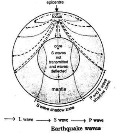
**Difference between Seismic Focus and Epicentre**:
The seismic focus (or hypocentre) is the exact point deep underground where the earthquake originates, while the epicentre is the location on the Earth's surface directly above the focus, where seismic waves first strike and cause the strongest shaking.
In simple words: The three kinds of earthquake waves are P-waves (fastest), S-waves (secondary), and L-waves (surface waves, which cause the actual damage). The focus is the underground starting point of the quake, and the epicentre is the beach or ground surface directly above it.
Exam Tip: Remember that P-waves can travel through all mediums (solids, liquids, and gases), whereas S-waves can only pass through solid rock.
Question. What is the Tsunami ? How ist it produced ? What are its effects ?
Answer:
A tsunami (from the Japanese words 'Tsu' meaning harbour and 'nami' meaning wave) is a series of massive, highly destructive ocean waves that can rise several meters high as they crash onto coastal landforms. These harbor waves are generated by underwater tectonic activity, including submarine earthquakes that displace the sea floor, volcanic eruptions, coastal landslides, or large meteorite impacts. Upon reaching the coast, they flood towns, destroy structures, and cause widespread loss of life.
In simple words: A tsunami is a massive, destructive wave triggered by undersea earthquakes or volcanic eruptions. When it hits the shallow coast, it swells to many meters high, causing massive flooding and damage.
Exam Tip: Clarify that tsunamis are not tidal waves, as they are generated by seismic activity rather than gravitational tidal forces.
Question 3. Compare and contrast the constructive effects and the - destructive effects of an earthquake.
Answer:
**Constructive Effects**:
1. Energy Release: They allow the Earth to safely discharge built-up internal strain along plate boundaries, maintaining long-term geological stability.
2. Crustal Uplift: Tectonic movements can uplift sections of coastal land to form fertile plains, such as the 200 m uplift of Sagami Bay in 1923.
3. Lake Formation: Earthquakes can trigger mountain landslides that block rivers, naturally creating beautiful lakes in mountainous terrains like the Himalayas.
**Destructive Effects**:
1. Structural Collapse: Intense ground shaking collapses homes, buildings, and infrastructure, causing enormous loss of property and human life.
2. Submergence: Tectonic shifts can cause coastal plains to sink permanently under the ocean, as witnessed historically in Dwarka, Gujarat.
3. Alteration of Rivers: Earthquakes can shift the natural pathways of rivers, rendering agricultural lands dry and ruining local irrigation systems.
In simple words: Constructive effects include releasing excess heat/energy from the Earth and building new land or lakes. Destructive effects include the collapse of cities, the sinking of coastal areas, and changes to river pathways that harm farming.
Exam Tip: Make sure to present your answer using a comparative structure with headings for "Constructive" and "Destructive" effects.
Question 4. Is it possible to predict an earthquake ? Give reasons to support your answer.
Answer:
Currently, scientists cannot predict the exact timing, location, and magnitude of an earthquake. While early predictions relied on astrology, modern seismology is a highly scientific pursuit. Seismologists use various indicators, such as monitoring P and S wave patterns (first studied extensively by Russian scientists in the 1960s) and applying plate tectonics models. In Japan, researchers track ground deformation, variations in the Earth's magnetic field, and changes in sea levels. However, because the crust's behavior is highly complex, no foolproof prediction method exists yet.
In simple words: No, scientists cannot accurately predict when or where an earthquake will strike. They use advanced tools to monitor changes in magnetic fields, sea levels, and wave speeds, but the Earth is too complex for flawless predictions.
Exam Tip: Emphasize that while "early warning systems" exist to detect waves as they occur, "long-term prediction" remains an unsolved scientific challenge.
Question 5. How are earthquakes distributed over the globe ?
Answer:
Earthquakes are distributed along active plate boundaries and weak tectonic belts. The two primary seismic belts are:
1. **Circum-Pacific Belt**: Also known as the "Ring of Fire," this belt runs around the rim of the Pacific Ocean and experiences nearly 70% of the world's earthquakes.
2. **Mid-World Mountain Belt**: This belt runs across the Mediterranean, through Central Asia, and follows young fold mountains like the Alps and the Himalayas, which are still actively growing.
In simple words: Earthquakes are concentrated along tectonic boundaries. The most active areas are the Circum-Pacific "Ring of Fire" and the Mid-World Belt running through the Alps and the Himalayas.
Exam Tip: Use the term "Ring of Fire" and describe it as a highly active subduction zone to add geologically sound terms to your answer.
Question 6. How is the intensity of earthquakes measured ? What instruments are used ?
Answer:
Seismologists use two main scales to measure earthquakes:
1. **Richter Scale**: This scale measures the magnitude (energy released) on a scale of 1 to 9, calculated from the zigzag wavelength patterns recorded on a seismograph.
2. **Modified Mercalli Scale**: This scale measures the intensity (observable damage and impact on humans) from a scale of 1 to 12.
The primary recording instrument used is the **Seismograph**.
In simple words: We use a seismograph to record earthquake waves. The Richter scale (1 to 9) measures the energy released, while the Mercalli scale (1 to 12) measures the visual damage caused.
Exam Tip: Clearly distinguish between magnitude (measured by the Richter scale) and intensity (measured by the Mercalli scale).
Practice Questions (Solved)
Question 1. (a) What is an Earthquake ? (b) How it is caused ? (c) Describe the world’s distribution of earthquakes. (d) What are the advantages and disadvantages of Earth quakes. OR What are the effects of Earthquakes ? (e) Name the major earthquakes of India from 1991 to 1997.
Answer:
(a) An earthquake is a sudden, violent vibration or shaking of the Earth's crust caused by tectonic movements or volcanic forces.
(b) Key causes include:
1. Volcanic activity, where rising magma and explosive gases trigger localized tremors.
2. Cooling and contraction of the Earth's interior, causing the outer crust to crack and fault.
3. Subterranean steam pressure, where water seeps deep into the crust, heats up into expanding steam, and forces its way out.
(c) Earthquakes are distributed along major tectonic belts, namely the Circum-Pacific Belt (Ring of Fire) and the Mid-World Mountain Belt along young fold mountains.
(d)
- **Disadvantages (Destructive Effects)**: They destroy buildings and cities, cause landslides that block rivers, and trigger massive coastal-flooding tsunamis.
- **Advantages (Constructive Effects)**: They release excess internal energy, push precious metals and minerals up to the surface, and uplift coastal plains.
(e) Major earthquakes in India between 1991 and 1997 include the Latur earthquake of 1991 and the Uttarkashi earthquake of 1993.
In simple words: (a) An earthquake is a sudden ground shaking. (b) It is caused by volcanoes, contracting rocks, or underground steam pressure. (c) Most happen in the Pacific Ring of Fire or alpine mountain belts. (d) They are harmful because they destroy cities, but helpful because they release trapped energy and bring up minerals. (e) Famous Indian earthquakes include Latur (1991) and Uttarkashi (1993).
Exam Tip: Break your answer down using labeled sub-parts to ensure you address every section of this multi-part question.
Question 2. Name the important Earthquake-belts of the world. OR Indicate two major belts of Earthquakes.
Answer:
The two primary earthquake belts of the world are:
1. **Circum-Pacific Belt (Ring of Fire)**: This highly active belt surrounds the Pacific Ocean basin, running along the west coast of the Americas and the east coast of Asia.
2. **Mid-World Mountain Belt**: This belt runs across the Mediterranean, through Central Asia, and into the East Indies. While seismically active, it is generally less intense than the Circum-Pacific belt.
In simple words: The two main earthquake belts are the Circum-Pacific Belt (which runs around the Pacific Ocean) and the Mid-World Belt (which runs through the Mediterranean and Asia).
Exam Tip: Make sure to state that the Circum-Pacific belt is the most seismically active region on Earth.
Question 3. Name the instrument used to record Earthquakes.
Answer:
The instrument designed to detect and record the vibrations of earthquake waves is called a **seismograph**.
In simple words: The tool used to measure and record earthquake waves is called a seismograph.
Exam Tip: Keep this definition simple and spell "seismograph" correctly.
Question 4. Name some Earthquakes which caused great damage.
Answer:
Several highly destructive earthquakes throughout history include:
1. The Lisbon Earthquake of 1755
2. The Tokyo (Japan) Earthquake of September 1923
3. The Quetta Earthquake of 1935
4. The Tangshan (China) Earthquake of July 1976
5. The Bhuj (Gujarat, India) Earthquake of 2001
In simple words: Some of the most destructive earthquakes in history include those in Lisbon (1755), Tokyo (1923), Tangshan (1976), and Bhuj, India (2001).
Exam Tip: Mentioning the 2001 Bhuj earthquake is particularly relevant for Indian curriculum papers.
Question 5. Earthquakes occur in the Mid-Atlantic belt.
Answer:
Earthquakes occur frequently along the Mid-Atlantic Belt because of seafloor spreading. As the North American and Eurasian tectonic plates pull apart, magma rises to form new oceanic crust, generating constant volcanic activity and shallow-focus earthquakes along the divergent boundary.
In simple words: Earthquakes happen along the Mid-Atlantic belt because the sea floor is spreading apart as tectonic plates move away from each other.
Exam Tip: Frame this around "divergent plate boundaries" and "seafloor spreading" to show a strong geological vocabulary.
Question 6. How do earthquakes affect landscape ?
Answer:
Earthquakes profoundly alter landscapes in the following ways:
1. They cause the vertical and lateral displacement of landmasses, creating steep cliff faces known as fault scarps.
2. They trigger devastating landslides and rockfalls in mountainous areas.
3. They can offset or block river channels, altering stream directions.
4. Seismic waves physically fracture rock surfaces and buckle roads, railways, and underground piping.
In simple words: Earthquakes alter the land by causing landslides, shifting river paths, creating steep cliffs, and breaking apart roads and railways.
Exam Tip: Use terms like "fault scarps" and "subsidence" to describe how earthquakes modify topography.
Question 7. What was the cause of Koyna earthquake in India ?
Answer:
The Deccan Plateau, where the Koyna Dam in Maharashtra is located, was historically considered a highly stable seismic zone. However, the construction of the massive reservoir allowed an immense volume of water to accumulate. This excess water pressure disturbed the local isostatic balance of the crust and lubricated deep-seated rock fractures, triggering a major earthquake in 1967 (referred to as reservoir-induced seismicity).
In simple words: The Koyna earthquake was triggered because the water collected in the massive reservoir was too heavy, putting intense pressure on the underground rocks and disrupting the area's geological balance.
Exam Tip: Clearly describe this as a prime example of a "man-made" or "reservoir-induced" earthquake.
Question 8. Describe the main type of Earthquake Waves.
Answer:
There are three main classes of earthquake waves:
1. **Longitudinal (or Primary 'P') Waves**: These are fast-moving compressional waves that travel through solid, liquid, and gas layers by compressing and expanding particles in the direction of wave travel.
2. **Transverse (or Secondary 'S') Waves**: These are shear waves that only travel through solids, causing rock particles to vibrate perpendicular (at right angles) to the direction of wave movement.
3. **Surface (or Long 'L') Waves**: These are slow-moving waves that travel along the outer surface of the Earth's crust, causing the most destructive ground motion.
In simple words: The three kinds of earthquake waves are P-waves (fastest, push-pull waves), S-waves (slower, side-to-side waves), and L-waves (slowest, destructive surface waves).
Exam Tip: Memorize the propagation differences - P-waves pass through solids and liquids, while S-waves are blocked by liquids - to answer seismic propagation questions.
Question 9. Name the causes of earthquakes.
Answer:
The primary factors causing earthquakes include:
1. Violent volcanic eruptions.
2. Geological faulting and fracturing of rock layers.
3. Elastic rebound of rocks under immense tectonic stress.
4. Local human factors (like dam building, mining, or deep waste disposal).
5. Large-scale epeirogenic crustal movements.
In simple words: Earthquakes are caused by volcanoes, shifting crust faults, the snapping back of bent rocks, and human activities like building large dams.
Exam Tip: Be sure to list both natural (tectonic/volcanic) and human-induced (reservoir/mining) causes.
Question 10. Why are earthquakes related to volcanoes ?
Answer:
There is a strong spatial correlation between earthquakes and volcanoes because both occur along active tectonic plate boundaries, particularly the Circum-Pacific Belt and the Mid-World Mountain Belt. During volcanic activity, the violent movement of rising magma and gases fractures surrounding rock layers, directly triggering local earthquakes. Thus, volcanic eruptions serve as a key localized cause of earthquakes.
In simple words: Earthquakes and volcanoes are closely related because both happen along the same boundaries of moving tectonic plates, and explosive volcanic eruptions directly shake the surrounding ground.
Exam Tip: Emphasize their shared spatial distribution along plate boundaries, like the "Ring of Fire," to explain their close relationship.
Free study material for Geography
ICSE Voyage Solutions Class 9 Geography Chapter 8 Earthquakes
Students can now access the detailed Voyage Solutions for Chapter 8 Earthquakes on our portal. These solutions have been carefully prepared as per latest ICSE Class 9 syllabus. Each solution given above has been updated based on the current year pattern to ensure Class 9 students have the most updated Geography content.
Master Voyage Textbook Questions
Our subject experts have provided detailed explanations for all the questions found in the Voyage textbook for Class 9 Geography. We have focussed on making the concepts easy for you in Chapter 8 Earthquakes so that students can understand the concepts behind every answer. For all numerical problems and theoretical concepts these solutions will help in strengthening your analytical skill required for the ICSE examinations.
Complete Geography Exam Preparation
By using these Voyage Class 9 solutions, you can enhance your learning and identify areas that need more attention. We recommend solving the Geography Questions from the textbook first and then use our teacher-verified answers. For a proper revision of Chapter 8 Earthquakes, students should also also check our Revision Notes and Sample Papers available on studiestoday.com.
FAQs
You can download the verified Voyage solutions for Chapter 8 Earthquakes on StudiesToday.com. Our teachers have prepared answers for Class 9 Geography as per 2026-27 ICSE academic session.
Yes, our solutions for Chapter 8 Earthquakes are designed as per new 2026 ICSE standards. 40% competency-based questions required for Class 9, are included to help students understand application-based logic behind every Geography answer.
Yes, every exercise in Chapter 8 Earthquakes from the Voyage textbook has been solved step-by-step. Class 9 students will learn Geography conceots before their ICSE exams.
Yes, follow structured format of these Voyage solutions for Chapter 8 Earthquakes to get full 20% internal assessment marks and use Class 9 Geography projects and viva preparation as per ICSE 2026 guidelines.